U Oregon App Helps Plan for Safe Fall Return to Campus
- By Dian Schaffhauser
- 06/16/20

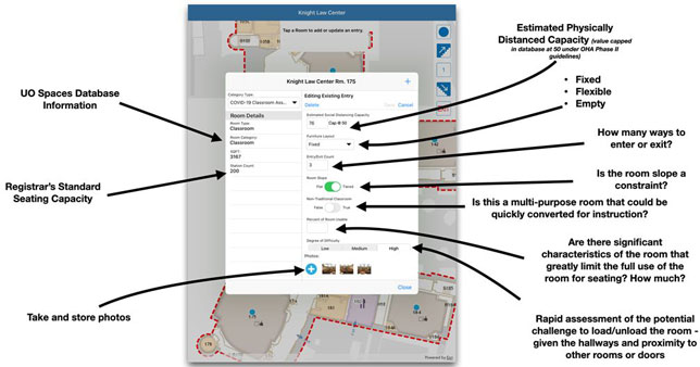
A sample layout of the University of Oregon app being used to help with physical distancing decisions. Source: the University of Oregon
A university in the northwest is using mobile mapping technology to sort out plans for the fall return to campus. The University of Oregon's "Chief Resilience Officer," Andre Le Duc, called on Ken Kato, director of the institution's Campus GIS and Mapping Program, to customize a mapping app to help with physical distancing decisions.
Kato's group, which is a division of Safety and Risk Services, has ample experience in "story mapping," having built software programs to help people track campus construction projects, lead mitigation work and winter storm paths and hazards. The projects use room-level information to enable a virtual mapping pin to be dropped into any space on campus, which can then be mixed with other data to develop the maps.
The latest project required a reconfiguration of the mapping tools to help the school define appropriate physical distancing protocols that followed state and federal guidelines in classrooms, labs, residence halls and other campus facilities. As a university article explained, "One of the big issues is how to reconfigure space on a nearly 150-year-old campus that was designed to bring people together to learn, not keep them apart." The goal was to figure out how rooms could be used for fall classes while allowing a 6-foot diameter space per student.
"The world has changed and every college campus has to figure out how it's going to use space differently, how it can bring students back safely following public health experts' physical distancing protocols," noted Le Duc. "Where rooms once had a fire code occupancy or instructional occupancy, the UO is building a COVID-19 occupancy." He added that spaces not meeting "the threshold for physical distancing are not an option. The first step in resuming in-person classes is to understand what spaces on campus can be utilized."
Once the mobile application was modified, members of University Fire Marshal Group and Environmental Health and Safety fanned out across campus armed with tape measures and laser measuring tools. Their job was to reassess the spacing of 300 classrooms and expand the map database even further with photos of entrances and exits, and variables such as fixed or movable furniture. Armed with the app, the staff finished the work in days versus weeks or months, according to the university.
The mapping information has gone to the offices of the provost and registrar, so that they can begin scheduling 3,350 classes and sorting out the modifications that will have to be made to ensure spaces will allow for physical distancing between students, faculty and staff.
The task force in charge of return-to-campus decision-making is planning for a hybrid approach. Those classes with fewer than 50 students will take place in person; those larger will be taught remotely. The university has projected that a sufficient number of core classes will be available online to accommodate students who want to carry a full course load and continue studying remotely.
About the Author
Dian Schaffhauser is a former senior contributing editor for 1105 Media's education publications THE Journal, Campus Technology and Spaces4Learning.