Carnegie Mellon and NASA Size Up Wildfires
- By Dian Schaffhauser
- 09/07/11
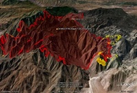
An example of a hot spot overlay |
As wildfire season heats up in the western United States, Carnegie Mellon University's Silicon Valley Campus is teaming up with NASA during September and October to further test out new approaches and technologies for managing emergency response. Wildfire Research and Applications Partnership, or WRAP, uses unmanned aerial vehicles (UAVs) to collect and distribute real-time wildfire image data to a mobile emergency operations center on the ground hundreds or thousands of miles away.
The NASA WRAP high-altitude data collection efforts have been underway since 2004; Carnegie Mellon's participation began more recently.
Exercises held earlier this summer between the two organizations evaluated the operations of sensors, software, and communications systems for performing real-time mapping and observation of wildland fires in New Mexico and San Diego County from the UAVs. These robot aircraft typically fly at an altitude between 20,000 feet and 50,000 feet capturing high-detailed imagery both visual and infrared. Software that compensates for the altitude, tilt, and roll of the UAV then "drapes" the images over Google maps and feeds the images to fire commanders on the ground. In this case the fires were in New Mexico and San Diego County, while mission control was on the Carnegie Mellon campus in Northern California.
Researchers involved in the work indicated that the same mapping approach could be just as valuable in other disaster scenarios covering a large geographic area, including earthquakes and oil spills. "We've had the ability to get aerial imagery for a long time, but we've never had a capacity like this for putting together a precise yet wide-area operating picture in real time," said Art Botterell, disaster management expert and Carnegie Mellon's Next-Gen Emergency Operations Center (EOC) consultant. "And advanced computer image analysis promises to help us detect things like natural gas leaks that simple 'eyeball' review of the images can easily miss."
On the ground, Carnegie Mellon contributed the use of its EOC, which runs out of two solar-powered 18-foot trailers. The trailers are encased in "smart bubbles," low-energy IT and communications gear and connected via WiFi and radio technology to disaster management applications running from the university itself, providing a portable space that's highly connected and technically sophisticated. This approach is a reversal of the standard emergency center practice, in which emergencies are managed from protected sites that are isolated from the effects of the disaster.
During the next couple of months teams from NASA and Carnegie Mellon will be on 24-hour alert to cover developing wildfires. The joint mission with NASA is one of a number of activities in Carnegie Mellon's Disaster Management Initiative, a research and development center established in 2009 with a focus on developing new open and interoperable technologies to address disasters.
Other projects at the university currently include:
- Analysis of social media's growing role in disaster response;
- Improving coordination among mobile command centers;
- Energy efficiency and sustainability; and
- Advanced visualization techniques for shared situational awareness.
About the Author
Dian Schaffhauser is a former senior contributing editor for 1105 Media's education publications THE Journal, Campus Technology and Spaces4Learning.