Location-Aware Services >> Where on Earth...?
- By Charlene O’Hanlon
- 02/01/07
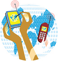
As ubiquitous computing efforts expand, the need to know where other people and devices are becomes critical to split-second decision-making. The question is: Will higher ed lead the LAS movement for the mainstream, as well?
 Ask any college student attending a university
in the Northeast or Midwest, and you'll discover that in the world
of frigid-winter academia, there is nothing worse than just missing
the campus shuttle bus in 12-degree weather. Today, however, students
at a handful of colleges can stay warm and cozy inside their dorm
rooms while they track the location of the shuttle bus on their cell
phones—all thanks to the implementation of location-aware services
(LAS) on their campuses.
Ask any college student attending a university
in the Northeast or Midwest, and you'll discover that in the world
of frigid-winter academia, there is nothing worse than just missing
the campus shuttle bus in 12-degree weather. Today, however, students
at a handful of colleges can stay warm and cozy inside their dorm
rooms while they track the location of the shuttle bus on their cell
phones—all thanks to the implementation of location-aware services
(LAS) on their campuses.
But just what are location-aware services? To put it simply, they
are applications that deliver location-based information whenever
and wherever it may be needed. Ideally, these services are accessed
via whatever means is convenient to the user: mobile phone, PDA,
pager, laptop, or desktop. LAS is part of the larger location-based
solutions (LBS) picture that comprises GPS-enabled mobile computing
services (communication and computation via mobile devices),
location-enabling services (used for user-locating), and locationaware
services (IP-based applications).
The Campus: Ideal Environment for LAS
In a nutshell, the technology behind LAS enables people, computers,
and other devices to know, within a few feet, where another is, at all
times; such services or applications then allow individuals—or their
devices—to make "decisions" based on that knowledge. There has
been much talk recently about the over-hyping of these kinds of services;
for instance, Gartner's July report, Hype Cycle for Wireless
Hardware, Software and Services, 2006, which
details high expectations for LAS, now climbing out of a mainstream
adoption "trough" and finally heading into a two-year adoption forecast.
But the fact of the matter is that LAS may take off faster on US and worldwide campuses than in the
general consumer environment. That's
because via their devotion to web tools
such as MySpace, Facebook, and
newer campus-generated social networking
offerings, college and university students
are now accustomed to "social
networking" applications and thus are
conditioned to communicating with
each other 24/7 via the campus intranet
or the web. Yet, this kind of connecting
takes place in the virtual world only.
What if kids want to "connect" with each
other in person, almost as instantly as
they connect online? What if they want
to find things they need in the physical
world—a bus ride, a pizza, a study
resource—as easily as they locate things
in the virtual universe?
As it turns out, any number of technology
providers has anticipated this eventual
need of the mainstream consumer.
What's more, the partnering among computing
and mobile computing device
makers, wireless service providers, geographic
information systems (GIS), and/
or global positioning systems (GPS) vendors
has been quietly going on behind the
scenes for some years, with huge players
like Nokia, Sprint Nextel jockeying for a
leading edge. Much academic discussion
has centered on the need for open standards
in this area, but even with that as an
obstacle, and the emergence of only a
smattering of players in the dedicated
application space—WaveMarket and education-focused
Rave Wireless are two—location-enabled services (comprising
both LAS and LBS) have been
predicted to become an $8- to $11-billion
business by 2008 (depending upon what
you read and who you speak to).
Still, despite slow adoption by the general
public, the uses of LAS on college
and university campuses appear to be
wide-ranging, from tracking the nearest
campus shuttle bus (our opening example),
alerting the campus community of
inclement weather conditions or other
potential threats to safety, and monitoring
a student's progress as he or she crosses
an urban campus late at night, to the simple
act of quickly finding a study buddy
or tracking a pizza delivery van. Not surprisingly,
colleges are beginning to
embrace (or at least look seriously at)
LAS as a value-add for their students, and
also as a useful teaching and learning tool.
FACTBOX
It is now possible for MIT's campus
community members to quickly locate
each other via laptop. The "friendspotting"
capability is enabled by almost 3,000
WiFi access points, boasts a highly precise
positioning system, and was designed
with particular attention to privacy and
data storage issues: There is no centralized
storage of data, and everything
happens via encrypted peer-to-peer
transmission among users.
The fact of the matter is, locationaware
services are a natural outcropping
of today's more useful—and used—technologies.
LAS incorporates the GPS
technology that (to comply with federal
E911 regulations) is now standard on
most cell phones. In addition, most college
students are now equipped with cell
phones: The Educause Center for Applied Research reports that 91 percent of post-secondary
students carry and use a cell phone. That
figure is no doubt growing: According to
CTIA, The Wireless Association (formerly the Cellular Telecommunications
Industry Association), cell
phone usage in the US, in general,
increased to 207.9 million users in 2005,
over 182.4 million the year before.
The Brave and the Few
As it stands now, though administrators at
many higher ed institutions are assessing
the need for using LAS to enable emergency
notification, shuttle-bus tracking,
or just plain "friend-finding" (the next hot
campus tech term), it's hard to find LAS
well-implemented on a US campus—or
at least, it's tough to find it well-thoughtout.
Leave it, of course, to MIT pioneers
to shrug off the budding (if not adolescent)
crop of application providers in the
LAS space, and boldly develop their own
solution, iFIND. iFind was expressly
designed by the researchers in MIT's
SENSEable City Laboratory (in conjunction
with the Information Services and
Technology department) to make it possible
for any of the 20,000 constantly
mobile campus community members
accross the Institute's 168 acres to locate
anyone else, via laptop. At MIT, the new
capability is called "friendspotting," and
is enabled by almost 3,000 WiFi access
points. The system, with its "extremely
precise" positioning system, was designed
with particular attention to privacy and
data storage issues. Thus, there is no
centralized storage of data, and everything
happens via encrypted peer-to-peer transmission among users.
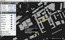
WITH iFIND, STUDENTS AT MIT can track down
friends for impromptu study groups or meet with faculty
members who happen to be nearby on campus.
"iFind is device-centric, not networkcentric,"
explains Carlo Ratti, director of
the SENSEable City Lab. "All the intelligence
is inside the client application
instead of a central server, so nobody can
track your position unless you want him
to, and you decide how to exchange information
with the outside world." Though
iFIND currently deals with location data,
a whole array of additional personal
information could be managed using the
same interface and platform. Right now,
iFIND helps MIT campus community
members find each other quickly ("Imagine
coming out of a class in a far-off corner
of the MIT campus, and instantly
knowing which friends are nearby, or
being able to schedule an appointment
with a faculty member, based on his or
her proximity to you," says Ratti), but
future applications of the system will
include the ability to select third parties
as "friends" and let them share data
anonymously. (An iFIND user could, for
instance, let the police department know
where a given student is, in case of emergency,
and yet not reveal the student's
identity up front.)
At Montclair State University (NJ), a
rush to wireless leadership (as in the case
of MIT) wasn't necessarily the driver
behind the institution's LAS initiative;
administrators and technicians were simply
grappling with a shortage of landlines
and the need to stay in touch with the
institution's student population, recounts
Edward Chapel, associate VP for IT. Noting
the burgeoning use of cell phones on
campus, university officials decided to
develop a cellular infrastructure. Then,
"We decided that if we were going to go
to the trouble of instituting a cellular network,
we might as well see what else we
could do with it," he says.
An early adopter of LAS, MSU actually
launched a pilot of the technology two
years ago. The college partnered with
Rave Wireless (a provider of mobile apps
and mobile phone offerings geared
specifically to the higher ed space) to
develop applications that eventually
would become the cornerstone of the college's
recently launched Campus Connect
program. "We were [Rave's] maiden voyage,
and they have since taken some of
our applications and built a standard portfolio
around them," Chapel says.
FACTBOX
Montclair State University (NJ) is
an early adopter of three Rave Wireless location-aware
offerings: a shuttle bus locator service
(tracks exact location and ETA), a security
service (students can register their treks
across campus and the system alerts
campus police of non-responsiveness),
and a social networking service that helps
students locate the whereabouts of
"community" buddies.
Indeed, Montclair's location-aware
services include Rave's three most popular
offerings: Rave Transit, a shuttle
bus locator service that incorporates
transponders on each bus to track the
exact location and estimated time of
arrival; Rave Guardian, a security service
that, for safety purposes, enables a student
to register his trek across campus
and puts campus police on alert should
the student not check in within a reasonable
time period; and Rave Entourage, a
social networking service that enables
users to create communities and determine
the locations of community members
who want to be located—useful if a
student has two hours to kill on campus
but doesn't know where his buddies are.
For deploying LAS technology to protect
its students, MSU earned the 2006
Jeanne Clery Award from Security on Campus, a
nonprofit grassroots organization dedicated
to safe campuses for college and
university students. "That award was
gratifying because there is a tendency to
regard location-aware applications as
mere gadgetry, but now they are getting
some real traction in the higher ed space,"
Chapel says.
Today, as part of MSU's Campus
Connect program (and included in
tuition), all incoming students receive a
cellular handset. The program is mandatory,
because MSU also is using the cell
phones as data-collection tools in the
classroom. (Students take tests and
answer questions via the phones, and
results are compiled in real time. Not a
location-aware service, Chapel notes,
but one more value-add for students
and, in this case, faculty.)
For deploying LAS technology to protect
its students, Montclair State earned the
2006 Jeanne Clery Award from nonprofit
organization Security on Campus.
A Growing Trend
Increasingly, location-aware services are
being viewed as a good fit for higher ed,
most importantly because they open a
line of communication that did not previously
exist between student and college.
"Students these days don't read e-mail,
and they certainly don't read standard
mail," says Chapel, "so if you want to
get something out there that is actually
read, it can be done by text messaging.
[Employing] GPS, it's feasible to use
text messaging to target messages geographically—
say, to announce a class
cancellation due to inclement weather."
Raju Rishi, COO and co-founder of
Rave Wireless, sees text messaging as a
big selling point for his company's
applications. "The youth of today lives
and dies by text messaging," he maintains.
"Kids view it as their lifeline, and
they are more receptive to other applications
used in conjunction with the
phone, rather than using that device just
for voice transmission. The widespread
use of cell phones by students used to
represent a cultural gap, but now universities
are seeing that they can leverage that device usage to their advantage."
Ronald Forsythe, VP for planning,
assessment, technology, and commercialization
at the University of Maryland Eastern Shore, agrees. "There will be a
large percentage of higher education
institutions offering these services
because they realize [the technology will]
help them communicate with the students."
UMES is rolling out the Rave
Wireless Guardian and Entourage apps as
part of the institution's Hawk Talk mobile
communications program. The college is
also looking at implementing a weather
service that provides weather and classcancellation
information to students,
based on their location. Though Hawk
Talk is currently an opt-in program,
UMES saw a nearly 60 percent "take"
rate for incoming students because of
the Guardian safety-focused application,
Forsythe notes. "We had a big discussion
with the students and parents explaining
the benefits of the program, and the
location-aware services were big sellers."
And at Wake Forest University (NC),
Jay Dominick, CIO and assistant VP for
information systems, insists students will
embrace LAS for learning, because they
mimic the more interactive learning style
already pervasive in modern society.
"Much of our reasoning behind the adoption
of location-aware services came
from watching the way younger kids
interact with their handheld games. In a
large sense, those are location-based
games," he points out. "Students engage
in experiential learning, and this is an
extension of that: It forces them to get out
of their seats and face a situation where
they have to figure out the best solution.
It's a new way of learning, and I'm hoping
that someone can use location-aware
services to implement a better way of
visualizing that." WFU is one of about 25
Rave Wireless higher ed customers, and
one of "only a handful" thus far using
location-aware services, Rishi discloses.
"We had a big discussion with the students and
parents
explaining the benefits of our Hawk Talk
mobile
communications
program, and the
location-aware services were big sellers."
—Ronald Forsythe,
University of Maryland Eastern Shore
Will Homegrown Take the Lead?
Following in MIT's footsteps, a number
of colleges are looking at homegrown
location-aware applications, or conducting
LAS-based research they hope
will someday make its way into the campus
infrastructure.
Norman Sadeh, associate professor for
the Institute of Software Research International
and the School of Computer Science
at Carnegie Mellon University
(PA), has been working on the MyCampus
location-aware project for about six
years. Collaborating with a student
population that spans undergraduates
through Ph.D. candidates in the university's
Human-Computer Interaction
(HCI) program, Sadeh has been looking
at the impact of policies on the acceptance
of LAS in different scenarios.
"Policies can range from where you
are, what time of day it is, what your relationship
is to another person, what day of
the week it is, and the list can go on." But,
"trying to get students to specify a few
options is impossible," Sadeh says. "We
experimented with different interfaces,
put people in different scenarios, and had
them create their policies based on those
scenarios. What we found was that students
were happy with the outcome only
60 percent of the time. If the student was
able to modify each policy with each different
scenario, his or her satisfaction rate
increased only to 70 percent."
What does all of this policy-based
investigation reveal? The bottom line,
says Sadeh, is that currently there is no
single solution that can please everyone,
and much more research must be conducted
to find an acceptable threshold for common situations. Through a recently
awarded National Science Foundation grant, Sadeh and his
group hope to discover that threshold.
"In part," he says, "we're trying to
learn preferences and then make decisions
based on those preferences,
without getting to 100 percent accuracy.
But is 99 percent enough? I
guess it depends on the situation.
We're looking at the broader problem
of trying to determine how much is
enough."
Some of the applications the MyCampus
developers have experimented with
include "recommendation" systems based
on location. They utilize parameters
such as time between classes, time of
day, weather, student tastes (in the case
of restaurant recommendations, for
instance), and calendar events. The recommendation
application was not very
successful in the limited campus environment,
but Sadeh believes this is one case
where an LAS system would fare better in
the general population—if only because
there simply are many more opportunities
for recommendations.
Interestingly, Sadeh notes that another
application, crime alerts, also did not
work well. But that was because, in this
instance, "We could not come up with the
right kind of interface, and the alerts
ended up frightening the students more
than helping them."
Some of the more successful projects
connected to MyCampus: a reminder system
that notifies a user of an event or a
task, based on current location (a student
traversing the campus passes the science
building and is alerted about a homework
or project assignment in the building that
he has yet to pick up), and a "virtual
poster" function. "Posters are tacked up
everywhere on campus," says Sadeh, "so
we looked at whether we could instead
put those into an LAS application which
allows the posters to be ‘retrieved' based
on where the user is on campus."
Privacy: The 800-Pound Gorilla
As with the MIT iFIND services, privacy
has been a primary consideration in
every MyCampus application. "It's a
very important element of our research,"
says Sadeh. "We've been looking at the
spectrum of privacy issues and what
people's privacy preferences are, but
different people have different preferences,
so it's hard to allow just two or
three options for everyone."
When it comes to location-aware services,
the argument is not that locationaware
services are an invasion of privacy;
but rather, how much privacy must one
give up in order to access such services?
Rave Wireless' Rishi insists the answer
to that question is: none. With any location-
aware service, he points out, users
decide whether they want to be located.
"We set important ground rules; universities
can't arbitrarily pick out location
data," he explains. "Students can choose
to activate their location services, or not;
it's strictly voluntary." He also maintains
that his company makes it clear to higher
ed clients that it does not pass on any user
information to the university. "Students
need that trust factor. Once it is set, these
services become more accepted."
Indeed, UMES' Forsythe claims that
students may have more to fear from their
parents than from a university's locationaware
services. "Parents actually want
more access. They want their child's
grades sent to them or they want us
to track the kids to make sure they're
going to class," he says. "But we tell
them, ‘No, we can't do that.'"
Yet despite those safeguards,
Carnegie Mellon's Sadeh admits
that as location-aware services
become more ubiquitous, both on campus
and in the general population, privacy will
become the 800-pound gorilla that can't
be ignored. "I don't see these applications
really taking off unless you take privacy
into account," he asserts. "Increasingly,
you see all these people who post things
on MySpace or Facebook that they later
regret posting. Slowly, people are learning
that some things need to stay private."
Rave is looking at a new application it
believes will both address privacy issues
and provide valuable location-based services.
Dubbed ID Wash, the program purports
to recognize an entity in a particular
location but not the identity of the entity.
This app would be suitable for measuring
the number of people using a particular
pathway at any time, for example, or
determining whether more shuttle buses
are needed on a given route, Rishi says.
At Carnegie Mellon University, Norman
Sadeh notes that the crime alert LAS
application did not work well in trials:
"The alerts ended up frightening the
students more than helping them."
Looking Ahead
As location-aware services continue to
take hold on campuses nationwide, the
applications that address safety, functionality,
and convenience for both the
students and the educational institution
will undoubtedly take center stage.
Mapping capabilities and device-aware
applications are among the possibilities
more frequently discussed by universities
already using location-aware services, as
well as human resources functions such
as time-clocking and inventory control.
UMES, for example, is looking at an
application that automatically clocks in
an employee when he or she crosses a
campus perimeter, and "pushes" work
orders to the employee's cell phone, based on the individual's location.
MSU is looking at similar LAS apps
for its IT department, which has a student
staff of about 150 and a full-time permanent
staff of 15. Says Chapel:
"This application would enable us
to locate where our employees are
on campus and, based on their
abilities and location, direct them
to their next service call rather than
have them come back to the
department and then turn around and go
right back out." This will result in less
time between calls and more calls completed
in one day, he says, but adds that
other application considerations may be
less obvious.
"Although some applications are too
complex to actually implement now, we
need to think ahead of the curve," says
Chapel. "But we've made some great
strides, and the pace of development, as
well as the reliability of the applications,
is impressive."
Still, the success of LAS clearly will
depend on the growing acceptance of
ubiquitous computing. "Ubiquity is the
always-on nature of devices, and I can
envision, at some point, total coordination
of those devices via location-aware
services," Chapel offers. "Broadband cellular
is the key to ubiquity, and cellular is
filling the gaps to allow applications to
seamlessly traverse networks."
WFU's Dominick sees LAS and ubiquitous
computing becoming tightly integrated
sooner, rather than later: "If you
look at the technology direction, carriers
are definitely looking to make that happen."
With initiatives like Verizon Wireless'
TheZON, carriers are currently
encouraging content and application
developers to help them make such ubiquity
(and the incorporated LBS) a reality.
It may be some time before they
are fully successful, but the integration
of GPS into the devices is
a decisive first step.
"Putting GPS into handsets not
only allows [the carriers] to fulfill
the 911 requirements, it also
enables data delivery," says Dominick.
"Plus, WiFi networks are becoming
more prolific, so connectivity is becoming
synonymous with location. Within
five years, everything will know exactly
where everything else is, at all times."
In the end, we all may wonder how we
managed to get along, moving around
obliviously.
WEBEXTRA :: For resources and related articles on wireless and mobile computing, click here.
EDITOR'S NOTE :: We welcome feedback from campuses and vendors engaged in LAS or LBS initiatives, for future coverage.
E-mail us at [email protected].